Paid
SERVICE DESCRIPTION | GLOBAL NAVIGATION SATELLITE SYSTEM (GNSS) HEADING GNSS Heading Veripos LD8 is a precision 3D (three-dimensional) positioning tool and heading of a survey vessel. GNSS Heading Veripos LD8 is capable of producing positions with sub decimeter…
- Laboratorium Alat Survei - Geospatial dan Kartografi
- KST Serpong (Bacharuddin Jusuf Habibie)
KST BJ Habibie Serpong Gedung 255 Laboratorium Alat Survei - 08119811551
- pengelolaan_alatsurvei@brin.go.id
Marketing Office
Deputi Bidang Infrastruktur Riset dan Inovasi BRIN
layanan_sains@brin.go.id
GLOBAL NAVIGATION SATELLITE SYSTEM (GNSS) HEADING
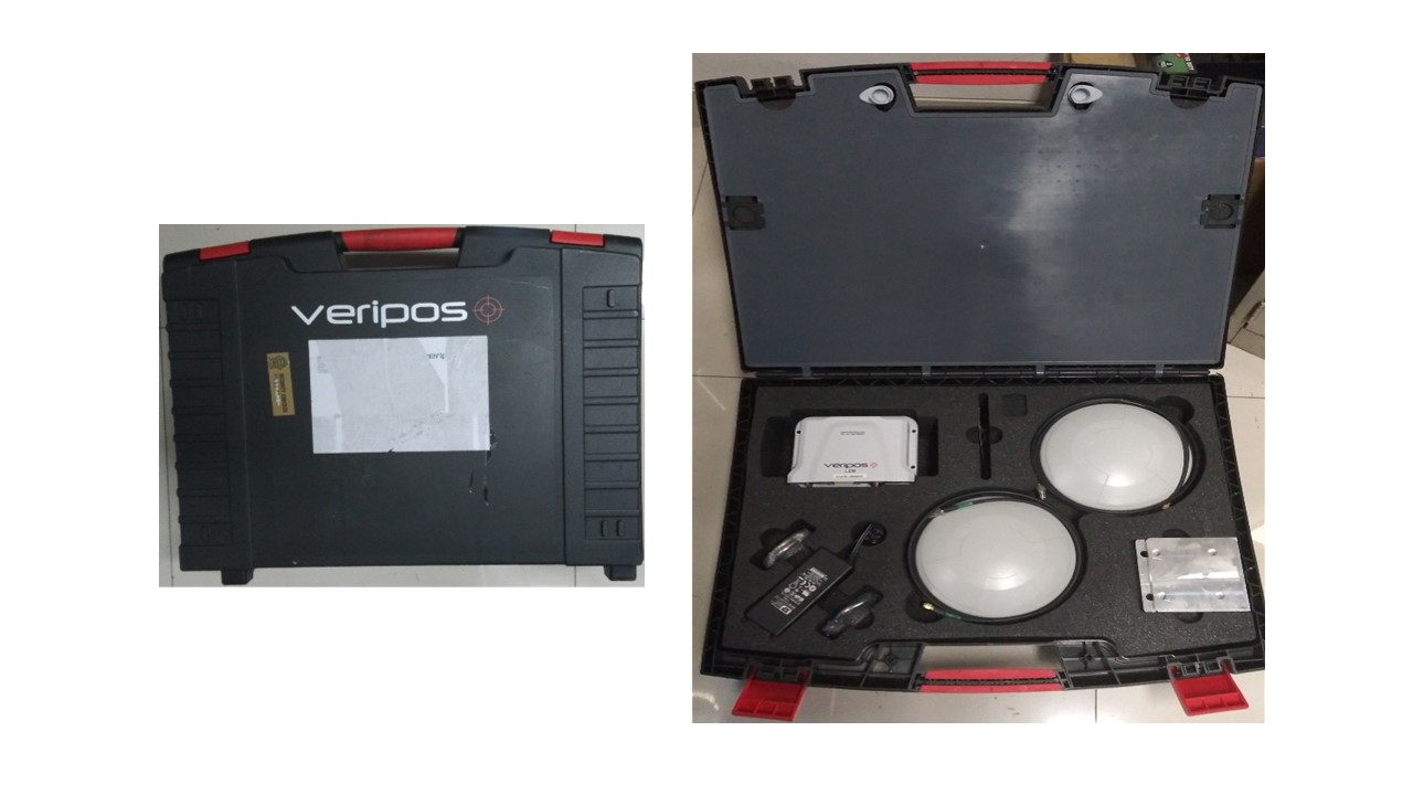
GNSS Heading Veripos LD8 is a precision 3D (three-dimensional) positioning tool and heading of a survey vessel. GNSS Heading Veripos LD8 is capable of producing positions with sub decimeter accuracy if it receives a Real Time Kinematic (RTK) system correction signal and heading accuracy of up to 0.1°, making it very suitable for survey applications at sea..
Brand:
Veripos LD8
Completeness:
Function:
SPECIFICATIONS
Performance
Channel configuration 555 Channels
Signal tracking
Primary RF
GPS L1 C/A, L1C, L2C, L2P, L5
GLONASS3 L1 C/A, L2 C/A, L2P, L3, L5
BeiDou B1, B2
Galileo E1, E5 AltBOC, E5a, E5b
SBAS L1, L5
QZSS L1 C/A, L1C, L2C, L5
L-band (Primary RF only) up to 5 channels
Secondary RF
GPS L1 C/A, L1C, L2C, L2P, L5
GLONASS3 L1 C/A, L2 C/A, L2P, L3, L5
Galileo E1, E5 AltBOC, E5a, E5b
BeiDou B1l, B1C, B2l, B2a
QZSS L1 C/A, L1C, L2C, L5
Horizontal position accuracy (RMS)
Single Point L1 1.5 m
Single Point L1/L2 1.2 m
SBAS 1 m
VERIPOS DGNSS 1 m
VERIPOS PPP 5 cm
RTK 1 cm + 1 ppm
Initialization time < 10> Initialization reliability > 99.9%
Maximum data rate
Measurements up to 20 Hz
Position up to 20 Hz
Time to first fix
Cold start < 39> Hot start < 20>
Signal reacquisition
L1 < 0> L2/L5 < 1> Time accuracy 20 ns RMS
Velocity accuracy 0.03 m/s RMS
Velocity limit 515 m/s
Align GNSS heading accuracy
Baseline Accuracy (RMS)
2 m 0.08 degrees
4 m 0.05 degrees
Communication ports
1 RS-232 up to 460,800 bps
2 RS-232/RS-422 selectable up to 460,800 bps
1 USB 2.0 (device) HS
1 USB 2.0 (host) HS
1 Ethernet 10/100 Mbps
1 Pulse Per Second output
Physical and electrical
Dimensions 147 x 125 x 55 mm
Weight 500 g
Power
Power consumption 6 W
Input voltage +9 to +36 VDC
2 Antenna LNA power outputs
Output voltage 5 VDC ±5%
Maximum current 200 mA
Connectors
2 Antenna SMA
USB device Micro A/B
USB Host Micro A/B
Serial, PPS DSUB HD26
Ethernet RJ45
Power SAL M12, 5 pin, male
Status LEDs
Power
GNSS
INS
Data Logging
USB
Environmental
Temperature
Operating -40°C to +75°C
Storage -40°C to +85°C
Humidity 95% non-condensing, ,EN60945
Ingress protection rating IP67
Vibration (operating)
Random MIL-STD-810 H
Method 514.6 (Cat24 24, 20 g RMS)
Sinusoidal IEC 60068-2-6
Acceleration (operating)
MIL-STD-810G, Method 513.6
Procedure II (16g)
Bump IEC 60068-2-27 (25g)
Shock (non-operating) MIL-STD-810G, 516.6,
Procedure 1, 40 g 11 ms terminal sawtooth
Compliance Industry Canada, FCC,
CE, UKCA, RoHS, WEEE, EN60945 (Protected Equipment), EN60950, EN62368, EN62479
Features
• NovAtel® OEM7® marine positioning engine
• 16GB of internal storage for rolling data logging and incident support
• Support for logging to external USB storage device
• Built in WiFi support
• WebUI
• OGP 373-19 and IMCA S015 (July 2011) QC compliant
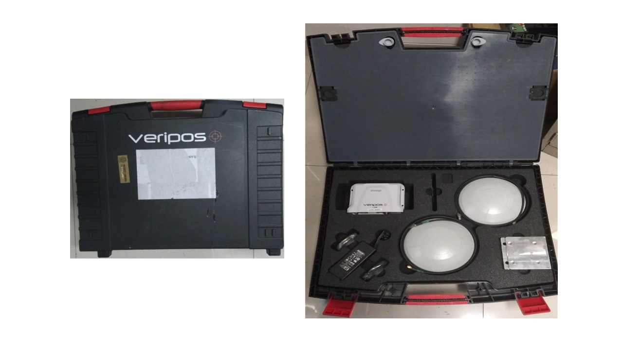
GNSS Heading Veripos LD8 is a precision 3D (three-dimensional) positioning tool and heading of a survey vessel. GNSS Heading Veripos LD8 is capable of producing positions with sub decimeter accuracy if it receives a Real Time Kinematic (RTK) system correction signal and heading accuracy of up to 0.1°, making it very suitable for survey applications at sea..
Brand:
Veripos LD8
Completeness:
- 2x Antenna
- Receiver and Control Unit
- 2x Antenna Cable
- 2x Antenna cable adapter TNC to SMA
- Squid Cable serial DB9 with D26 Connector
- Power Supply DC
- LAN Cable
- Suitcase
Function:
- Positioning and heading for Marine Navigation
SPECIFICATIONS
Performance
Channel configuration 555 Channels
Signal tracking
Primary RF
GPS L1 C/A, L1C, L2C, L2P, L5
GLONASS3 L1 C/A, L2 C/A, L2P, L3, L5
BeiDou B1, B2
Galileo E1, E5 AltBOC, E5a, E5b
SBAS L1, L5
QZSS L1 C/A, L1C, L2C, L5
L-band (Primary RF only) up to 5 channels
Secondary RF
GPS L1 C/A, L1C, L2C, L2P, L5
GLONASS3 L1 C/A, L2 C/A, L2P, L3, L5
Galileo E1, E5 AltBOC, E5a, E5b
BeiDou B1l, B1C, B2l, B2a
QZSS L1 C/A, L1C, L2C, L5
Horizontal position accuracy (RMS)
Single Point L1 1.5 m
Single Point L1/L2 1.2 m
SBAS 1 m
VERIPOS DGNSS 1 m
VERIPOS PPP 5 cm
RTK 1 cm + 1 ppm
Initialization time < 10> Initialization reliability > 99.9%
Maximum data rate
Measurements up to 20 Hz
Position up to 20 Hz
Time to first fix
Cold start < 39> Hot start < 20>
Signal reacquisition
L1 < 0> L2/L5 < 1> Time accuracy 20 ns RMS
Velocity accuracy 0.03 m/s RMS
Velocity limit 515 m/s
Align GNSS heading accuracy
Baseline Accuracy (RMS)
2 m 0.08 degrees
4 m 0.05 degrees
Communication ports
1 RS-232 up to 460,800 bps
2 RS-232/RS-422 selectable up to 460,800 bps
1 USB 2.0 (device) HS
1 USB 2.0 (host) HS
1 Ethernet 10/100 Mbps
1 Pulse Per Second output
Physical and electrical
Dimensions 147 x 125 x 55 mm
Weight 500 g
Power
Power consumption 6 W
Input voltage +9 to +36 VDC
2 Antenna LNA power outputs
Output voltage 5 VDC ±5%
Maximum current 200 mA
Connectors
2 Antenna SMA
USB device Micro A/B
USB Host Micro A/B
Serial, PPS DSUB HD26
Ethernet RJ45
Power SAL M12, 5 pin, male
Status LEDs
Power
GNSS
INS
Data Logging
USB
Environmental
Temperature
Operating -40°C to +75°C
Storage -40°C to +85°C
Humidity 95% non-condensing, ,EN60945
Ingress protection rating IP67
Vibration (operating)
Random MIL-STD-810 H
Method 514.6 (Cat24 24, 20 g RMS)
Sinusoidal IEC 60068-2-6
Acceleration (operating)
MIL-STD-810G, Method 513.6
Procedure II (16g)
Bump IEC 60068-2-27 (25g)
Shock (non-operating) MIL-STD-810G, 516.6,
Procedure 1, 40 g 11 ms terminal sawtooth
Compliance Industry Canada, FCC,
CE, UKCA, RoHS, WEEE, EN60945 (Protected Equipment), EN60950, EN62368, EN62479
Features
• NovAtel® OEM7® marine positioning engine
• 16GB of internal storage for rolling data logging and incident support
• Support for logging to external USB storage device
• Built in WiFi support
• WebUI
• OGP 373-19 and IMCA S015 (July 2011) QC compliant


